AGF-223 Remote sensing and space instrumentation (15 ECTS)
ID:
AGF-223
CREDITS:
15 ECTS
APPLICATION DEADLINE:
March 01, 2025
START DATE:
August 11, 2025
END DATE:
December 12, 2025
COURSE PERIOD:
Autumn semester. Teaching block 5-7
| Grade: | Letter grade (A through F) |
| Course Cost: | None |
| Course Capacity Min/Max: | 7/13 students |
| Language of instruction: | English |
| Examination support material: | Bilingual dictionary between English and mother tongue, non-programmable calculator. |
Course requirements
60 ECTS within the fields of mathematics and physics or a related discipline. The applicant must be enrolled in a programme at Bachelor level, or document that the courses are approved into the applicant’s current study programme.
The course should be combined with AGF-210 The Middle Polar Atmosphere.
These introductory courses are suitable for students in (any sub-field of) physics, astronomy, chemistry, engineering, geophysics, meteorology, environmental sciences or another related topic with basics physics skills.
Academic content
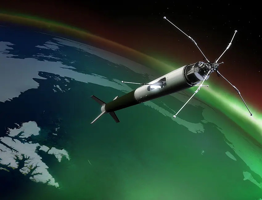
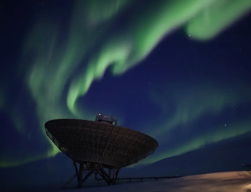
The course details instrumentation and techniques used in studies of the near-Earth environment. A basic introduction is given to the properties and processes in the near-Earth environment in the context of space weather, magnetosphere and ionosphere. Introduction to electronics and circuit design is also included. The remote sensing focus is on ground-based instrumentation for ionospheric processes, such as radars (HF and UHF), magnetometers and optics. The principles of spectroscopy, imaging and calibration of optical instrumentation are taught through lectures and laboratory work. The space instrumentation focuses on satellite, drone, and rocket-based instrumentation, such as Langmuir probes. Practical implications of making observations in-situ in the harsh environment of near-Earth space are discussed. A particular focus of the course is on how the Global Navigation Satellite Systems (GNSS) works and how space weather can affect the system.
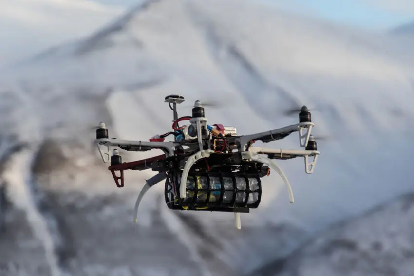
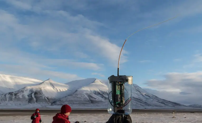
The students will gain an understanding of the various stages involved in planning a space mission through an online module. The students’ mission is to build, test and calibrate CanSats according to a basic space mission procedure. The CanSats will be deployed from a drone to measure vertical profiles of the lower atmosphere. The flight campaign part of the fieldwork is undertaken in collaboration with Andøya Space Education.
Learning outcomes
Upon completing the course, the students will:
Knowledge
- possess basic understanding of
- the physical processes involved in the coupling between the solar wind, magnetosphere and ionosphere
- ionospheric dynamics with a particular focus on the polar regions
- how ground-based instrumentation are utilized in the field of space physics
- GNSS and space weather influence on it
- be able to identify the key elements of a satellite and rocket mission from the scientific aims and planning through to the data analysis and interpretation of results
- understand simple circuits and circuit design
Skills
- be able to construct a CanSat based on predefined mission specifications
- be able to appraise and test the instrumentation in a controlled setting prior to drone launch
- be able to perform data analysis and interpretation from multiple data sets taken both in-situ and from the ground
- have gained familiarity and experience in working with optics, understand the functionality of the different components and investigate the limitations of the system
- be able to build and use simple electronic sensors
- be able to design and build a simple spectrometer, calibrate the system and analyse its measurements
General competences
- work effectively as a part of a team to build, test and calibrate instrumentation for CanSat
- be able to discuss and plan the various mission elements in terms of the science aims
- be able to collect and organize data for a poster presentation
- have an insight into the requirements of optical instrumentation
Learning activities
The course extends over a full semester. Initially, students attend four days of compulsory Arctic survival and safety training.
The lectures will be supported by interactive seminars where the students will learn to manipulate and combine datasets from a variety of instrumentation and relate them to physical processes in the near-Earth environment.
In small groups the students will be responsible for building, testing and calibrating a small instrument package for their CanSats, as well as collecting and analysing data from their CanSats. The results will be presented as individually designed posters. There will be an optical laboratory experiment where the students will build a basic spectrometer to investigate and discuss the principles of spectroscopy, imaging, and calibration.
The course also includes excursions to different ground-based research facilities nearby: the Kjell Henriksen Observatory, the EISCAT Svalbard radar and the Svalbard SuperDARN radar. Data from these installations will be used during the course. The course might also include an excursion to Svalsat
Summary
- Total lecture hours: Ca. 50 hours.
- Total seminar hours: Ca. 50 hours.
- Fieldwork / excursions: 5-8 days.
Compulsory learning activities
All compulsory learning activities must be approved in order to sit the exam.
- Fieldwork
- Lab work
Assessment
- All assessments must be passed in order to pass the course.
- Each assessment is graded, and subsequently combined into a single grade. Partial grades for each assessment will be available.
| Method | Duration |
Percentage of final grade
|
| Poster and oral presentation | 40% | |
| Written exam | 3 hours | 60% |
Student life