Marine drones on Svalbard

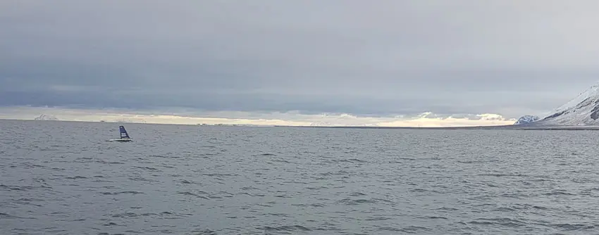
Top image: The sail buoy was deployed and gathered up again with the vessel UNIS Polaris. (Photo: Marcos Porcires/UNIS).
Mini-research ship lands safely in Longyearbyen after two month drift west of Svalbard.
11 November 2019
Text: Salve Dahle (Akvaplan-niva – Apn), Stig Falk-Petersen (Apn), Paul Renaud (Apn og UNIS), Jørgen Berge (UiT, NTNU og UNIS) and Trude Borch (Apn).
In late September a sail buoy arrived in Longyearbyen for the first time in history. It sailed into Isfjorden and was picked up by UNIS. This little “research ship” has been on an assignment west of Svalbard since early August.
The sail buoy is about two meters long, and it is loaded with a number of measuring instruments. This is a slider, i.e. it has no engine; its progress is taken care of by the wind, and it receives energy from a solar panel. The sail buoy is managed from Akvaplan-niva’s office in Tromsø, and the cruise is organized in collaboration with UNIS.
Background
Digitalization is changing at an ever-increasing pace our everyday lives, communities and industries. Multinational companies are developing a stream of new services and business models that are changing our lives – in the grocery store, within transport, travel, audio and visual experiences, communications, etc. Smartphones and tablets with ever-new features are central to ever more people’s lives. Also in the field of marine research, we can see that the wave of digitization is taking hold. With the help of marine drones, with and without engines, we can collect data from meteorology, oceanography and marine biology at high resolution in time and space from our office desk. These drones are controlled from a PC and the collected data is transmitted directly to the researchers via satellite. We can work with this in so-called “real time”. This reduces the time that goes from observation time to decision. (See fact box further down).
Need for updated “real time” observations
The Fram Strait between Svalbard and Greenland connects the northern Atlantic with the Arctic Ocean. 90% of the water exchange to and from the Arctic Ocean takes place through the Fram Strait, and most of the ice from the Arctic Ocean is transported through this stretch of sea. In recent years, heat transport into the Barents Sea, up along the west coast of Svalbard and into the Arctic Ocean has increased significantly. This is due to the fact that the amount of Atlantic water has increased and the temperature in this water is higher. This has helped to reduce the ice cover in the Arctic in general, and perhaps especially in the fjords along the west coast of Svalbard. In line with this, fisheries in the north are increasing, cruise tourism has exploded, and shipping is considering a shortcut across the Arctic Ocean during the summer. Through this, Svalbard gains an increased geopolitical significance.

Trial cruise in August 2019
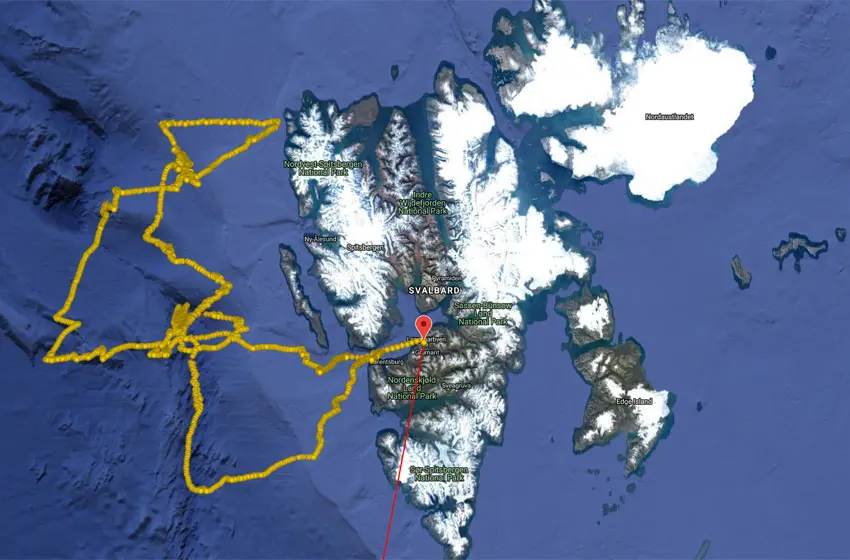
For the trial cruise in Svalbard, we chose to use a wind-driven glider; the sail buoy. The sail buoy was equipped with sensors that measure the salinity, temperature and oxygen content of the ocean as well as sonar that record the distribution and amount of fish and zooplankton in the water column. The planned route was to cross the Atlantic current and go north of Svalbard to the ice edge. This year the ice has been pushing towards the north coast of Svalbard, so the northernmost crossing was along the ice edge towards Amsterdamøya. During the summer and autumn, several research vessels have tried to enter areas northeast of Svalbard and into Rijpfjorden on Nordaustlandet to retrieve research instruments that are located on the seabed. All of these have had to turn around without results due to a lot of sea ice. The last time this happened in Rijpfjorden was in 2008. Now it may seem like a paradox that there seems to be more sea ice around Svalbard during a period when the Arctic is opening up and the ice is melting around us. But it is a fact that there is little ice in the Arctic. What is most likely to happen is that persistent winds from the north have gathered the ice north of Svalbard, so that both our drone and our research vessels have been forced to change the cruise plans. See the figures showing the ice conditions in our part of the Arctic and the sail buoy’s sailing.
Akvaplan-niva has been responsible for the sail buoy operation with the sail buoy, in collaboration with the University of Tromsø (UiT) and UNIS cruise with the vessel FF Helmer Hanssen and the Polish Academy of Sciences’s research ship Oceania. Offshore Sensing, NORCE and NIVA have been responsible for calibrating the instruments on the sail buoy and contributed to the daily operation of the drone. This is the first time that a continuous record of zooplankton (Calanus finmarchicus, Calanus glacialis, krill and amphipods) and fish larvae has been carried out in the upper 50 to 70 meters in the Atlantic inflow with high frequency sonar from a mobile platform.
One of the advantages of such a platform / glider is that it avoids the disturbances that would have been had the instruments been placed on a larger research vessel. The sail buoy also measures temperature, salinity and oxygen in the surface layer. Thanks to one collaboration over many decades between UNIS, UiT, Akvaplan-niva and Polish IOPAS, we are able to compare data from the sail buoy with samples collected in the traditional way from Helmer Hanssen, Oceania and the ocean observatories from UiT and UNIS. The samples collected from the glider and the two research vessels are planned to be analyzed during the autumn.
Fact box
The Glider project (2017-2019) is funded by the Research Council’s DEMO2000 program and the petroleum company ConocoPhillips. The project was developed under the leadership of Akvaplan-niva AS in Tromsø in collaboration with the project’s partners: Kongsberg Maritime and Kongsberg Digital, NORCE, Offshore Sensing, Aanderaa, Maritime Robotics, Norwegian Institute of Water Research (NIVA), the Meteorological Institute, UiT and Nord University. The project operates with two surface drones (gliders): a sail buoy (powered by wind and solar) and a wave glider (waves and solar energy), in addition to a diving glider. All three gliders are controlled by an operator from a PC and the collected data is sent directly to your PC via satellite. The purpose of the project is, among other things, to test the ability of the various platforms to operate and collect and transfer data under realistic conditions.
